
 About five miles east of the town of McCloud, a side road turns off Highway 89 at the sign for Fowler’s Campground. Over the next mile and a half, that road passes all three falls – Lower, Middle, and Upper – each with its own parking lot a short walk to the water.
This is the McCloud River, cutting through the Shasta-Trinity National Forest on its way down from Mount Shasta’s southern flank. Lower, Middle, and Upper Falls sit close enough together that you can walk the whole stretch on one trail or drive to each one separately – from parking lot to parking lot.
The full trail runs about 3.9 miles round trip, with a little over 300 feet of elevation gain, so it’s an easy-to-moderate hike. The first stretch, from the Lower Falls lot to Fowler Campground, is paved and wheelchair accessible. Past that, the surface turns to packed dirt, climbs a short run of switchbacks above Middle Falls, and flattens out again along the canyon rim to the Upper Falls overlook. Each fall also has its own parking lot, so you can skip the trail and drive the loop instead.
The canyon is made up of basalt – old lava, cooled and fractured into hexagonal columns stacked like fence posts along the walls. Douglas-fir and incense-cedar hold the slopes, with black oak and vine maple that turns color in October, when the umbrella plant (Darmera peltata, also called “Indian rhubarb”) along the water goes scarlet and orange. The undammed McCloud River is spring-fed, which is why it runs cold and clear even through the hottest months of summer.
Lower Falls
Park at the Lower Falls lot and the falls are close – a paved path from the kiosk, then a short two-flight stone staircase down to the water. This is the shortest of the three descents, built for the flip-flop-wearing visitor who wants to get close without committing to a hike.
The staircase leads to a plunge pool with a wide, rocky shelf for drying off in the sun. If you look closely, you’ll find old metal hooks embedded in a rock near the water and in it – reportedly the remains of a ladder swimmers once used to climb back out. The falls here are the smallest of the three, but the pool has the easiest access, which is why the parking lot fills first on a summer weekend.
Middle Falls
From Lower Falls, the trail continues less than a mile upstream, past Fowler Campground, before dropping down a short run of switchbacks to the base of the falls. If you’re driving instead, the dirt path down starts to the right of the overlook and gets you there just as fast.
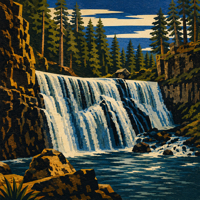
This is the one to see if you’re short on time. 50 feet tall and 100 feet wide, it’s the largest of the three by a wide margin, and the pool below it is the safest and most popular spot on the river to swim. A boulder field separates the viewing area from the water – climb it, and you’ll find more private stretches of the pool along the edges. The falls face west, so if you want the light on them rather than behind, come in the afternoon rather than at sunrise.
Upper Falls
The trail flattens out along the canyon rim above Middle Falls and ends at an overlook. There’s no maintained trail down to the water here, just an unofficial spur that drops steep and loose to the base. Most people stay up top.
What you can see from the overlook is a waterfall squeezed through a narrow gap in the basalt, 25 to 30 feet of water forced through a channel instead of spilling freely, which makes it sound stronger than its size would suggest. Past the last viewing deck, the trail keeps going another 13 miles upstream.
Getting There
From the town of McCloud: Highway 89 east for just over 5 miles. Turn right at the signed road for the McCloud River Loop, continue less than a mile, and stay right at the first intersection – the left fork leads to Middle and Upper Falls. Pass Fowlers Camp and turn left into the signed Lower Falls lot.
From Burney: Highway 89 north for around 40 miles, then left onto the Fowler Public Camp road.
From Dunsmuir: I-5 north to the Highway 89 South exit, then about 25 miles to a right turn onto the Fowler Public Camp road.
The road connecting the three falls is paved the whole way. In winter, the gate at Forest Road 40N44 closes just south of Highway 89, with a smaller parking area at the gate for the longer walk-in.
When to Go
Summer brings the best swimming (and the biggest crowds), along with heat that regularly hits 90 degrees.
October brings the color change along the water.
Wildflower season runs April through mid-June on the shrubby stretch between Fowler Camp and Middle Falls.
Weekday mornings are the closest you’ll get to having the place to yourself; arrive at sunrise on a summer weekend, and you might only see a lone fisherman at Lower Falls or maybe a photographer waiting on the light at Middle.
Safety and Respect
The boulders underwater here are a real hazard, and they are not always in the same place. What was a safe jumping spot one season can be a dangerous one the next, so treat every pool as unknown depth and skip the cliff-jumping regardless of what you’ve seen online.
Natural dangers – rattlesnakes, black bears, and mountain lions – are all possible in this stretch of forest. There’s usually no poison oak on the trail itself.
Fire restrictions tighten during the dry months – check current conditions with the McCloud Ranger District before firing up the grills or a campfire at Lower Falls picnic area.
History
Long before Highway 89 existed, the Shasta, Pit River, and Wintu people moved through this canyon each spring and fall to hunt elk, fish for rainbow trout, and gather medicinal plants along the river. Descendants of those tribes still live in the area, and the Pit River Tribe continues to work with the Forest Service on restoration projects along the McCloud today.
Good to Know
- No fee or permit for day use.
- A vault toilet sits at each of the three lots – bring your own hand sanitizer.
- Fowler’s Campground, next to Lower Falls, makes a good base if you want an early start; sites fill fast in summer.
- Dogs are welcome (on leash) at all three falls.
Land managed by: U.S. Forest Service, Shasta-Trinity National Forest, McCloud Ranger District, (530) 964-2184
Hours of Operation: Tuesday through Friday: 8:30 AM – 4:30 PM, Saturday: 8:30 AM – 12:30 PM, Closed Sunday, Monday, and Federal Holidays.