Tag Archives: Hiking

Wildwood Canyon Named a State Park — Trails, Birds, Open Country

State Park and Recreation Commission formally classifies Wildwood Canyon State Park; the Yucaipa day-use area — open since 2003 — now moves into long-range planning with California State Parks.

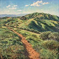
Wildwood Canyon was formally classified and named Wildwood Canyon State Park by the State Park and Recreation Commission at its regular meeting on Dec. 17. The designation folds the Yucaipa day-use area — open to hikers, equestrians, and mountain bikers since 2003 — into California State Parks’ portfolio with new planning and stewardship responsibilities attached. The change won’t close trails or alter views from a ridge, but it does set the stage for long-range decisions on access, conservation, and historic resources within the state agency’s authority.
 
Located about 75 miles east of Los Angeles and roughly 25 miles east of San Bernardino and Riverside, the park is a patchwork of scrub oaks, manzanita, yucca, and chamise with broad views over the surrounding valleys. It sits along the Pacific Flyway and supports more than 100 species of birds across the seasons; terrestrial inhabitants include mule deer, black-tailed jackrabbits, rattlesnakes, and occasional mountain lions, so visitors should treat the place like real country — keep dogs leashed, stay on maintained trails, and be aware at dawn and dusk. The property already serves trail users of multiple kinds and will continue to do so while planners and community partners work through the next phase.
 
State Parks’ Inland Empire District staff have signaled gratitude for local support and emphasized that the agency will coordinate planning with the public, California Native American tribes, and other stakeholders. That process will produce a cornerstone document and a general plan to guide decisions about recreation, resource protection, and potential restoration projects. There are nine buildings on site, and two of them have been flagged as candidates for nomination to the California Register of Historical Resources. This factor could influence restoration priorities and public access over time.
 
For anyone who rides or hikes in Wildwood Canyon, the practical bottom line is simple: the trails you know remain, but the park is now entering an era of formal planning backed by the state. Expect public outreach, the posting of planning documents on the park website, and a measured effort to balance visitor access with habitat protection and historic preservation. If you haven’t been, bring water, mind the wildlife, and follow the park’s updates as California State Parks shapes how this landscape will be managed for the years ahead.
 
You can find out more about our newest park on the California State Parks website HERE.

Camping and Hiking using CampingHiking.net

2020 was a difficult year for travelers, wanderers, adventurers, and explorers here in California. I did get out – sometimes with groups, sometimes furtively by myself – and was rewarded with solitude, silence, and freedom within the great cathedrals of nature that California offers from the deserts to the beaches, to the mountains and deep forests.

As with any exploration, it’s all about knowledge and preparedness. My hardware set is pretty solid – if I can’t get out of a jamb, I can call someone to come and find me – but this year my software set has been a bit lacking. 

Continue reading

The Solitary Trail

I’m not an introvert. I don’t suffer from Anthropophobia. In fact, I’m quite the social person. I just don’t like people.

As a hiker, I’m hardly the perfect specimen. So I clearly don’t hike for any of the physical benefits.

As an off-roader, I’m not a technical rockcrawler nor a long distance overlander.

Continue reading

Welcome to Rattlesnake Weather in California 2020

We’re all getting ready to go back outside. This year I’m planning on writing a couple of books about Jeeping, so I probably won’t be hiking as much as I’d like (much to my bathroom scale’s distress). I’ll still be out there – I’ve got a Mount Whitney hike planned for later this year, and I’ll be hitting some old favorites  (Mounts Wilson (14 miles, 5,710’ elevation), Baldy (10 miles, 10,064’ elevation), San Jacinto (11 miles, 10,834’ elevation), as well as Cucamonga Peak (11 miles. 8,859’ elevation), San Bernardino Peak (16 miles, 10,649’ elevation), and San Gorgonio (17 miles, 11,503’ elevation)).

Continue reading

Hiking Review: Quail Hill Loop

Quail Hill offers a few hiking, biking, and horse riding options from the Quail Hill Trailhead and Staging Area.  The Trailhead is located on Shady Canyon Drive, just past Fossil Road on the right.  To get there from the 405, take the Sand Canyon / Shady Canyon exit towards Shady Canyon Drive.  Enter the traffic circle and take the first exit to the right onto Shady Canyon Drive.  Turn into the first driveway on your right past Fossil.

I like the Quail Hill Loop for a few reasons, not the least of which is that it offers better views than you’ll find walking, jogging, or running around a high school athletic field.

Continue reading