
 I got an email asking about a sign that someone had seen up at Jenks Lake in the San Bernardino mountains. I hadn’t heard of any new signs, but checked it out. It appears that there’s a sign posted stating that there’s “increased satanic cult activity” in the area. The “sign” is an 8.5”x11” sheet of white paper printed with a inkjet printer and affixed with masking tape.
Tag Archives: USFS
 Next Level Camping is what I was looking for when I discovered you could rent fire lookouts. I’d been a member of the Forest Fire Lookout Association for years because I lived close to the Butler Peak Fire Lookout while up in Big Bear, and thought that I’d eventually be able to volunteer at the lookout. Solitude is always a draw for me, and the forest is my church. So going up to the steeple seemed like a pretty cool idea.
 The U.S. Forest Service Pacific has launched what they’re calling a “GIS map” (for those of us – like me – who are acronymically deficient, you can just call it the “geographic information system map) that provides information on the current status of campgrounds, day-use, picnic, and other designated recreation sites on national forest ground throughout California.
 From June 15 through June 19 California Air National Guard’s 146th Airlift Wing, Nevada National Guard’s 152nd Airlift Wing, the US Forest Service, the Bureau of Land Management, and CAL FIRE will be putting on quite an airshow for visitors to the Tahoe and Shasta/Trinity National Forests as these and other firefighting agencies train for aerial wildland firefighting.
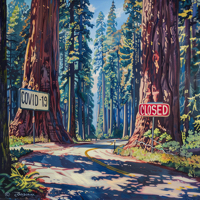 The U.S. Forest Service has announced that they’re going to postpone all new prescribed burns until further notice due to the Coronavirus. The canceled fire ignitions in California include burns in Six Rivers and Mendocino National Forests.
The U.S. Forest Service works in coordination with local and state health organizations when planning and managing prescribed burns and wildfires, and potential smoke impacts on the public are first and foremost in the planning process.