
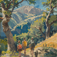
 If the holidays treated you right this season, you’ve got a few extra holiday calories you can safely let go of. What better way to do that than with a First Day Hike in the most beautiful state in the nation: California, the Golden State! This year marks the 10th year California State Parks has participated in the America’s State Parks First Day Hikes program with docents, volunteers, and staff hosting hikes at state parks throughout California on January 1st, 2020.
Category Archives: Day Hikes
Quail Hill offers a few hiking, biking, and horse riding options from the Quail Hill Trailhead and Staging Area. The Trailhead is located on Shady Canyon Drive, just past Fossil Road on the right. To get there from the 405, take the Sand Canyon / Shady Canyon exit towards Shady Canyon Drive. Enter the traffic circle and take the first exit to the right onto Shady Canyon Drive. Turn into the first driveway on your right past Fossil.
I like the Quail Hill Loop for a few reasons, not the least of which is that it offers better views than you’ll find walking, jogging, or running around a high school athletic field.

Friends of Echo Mountain have posted on Facebook about a fundraiser this Sunday, January 25. From Facebook:
Busy Sunday? There will be a fundraiser at the historic Sturtevant Camp in the Santa Anita canyon area. The camp is located approximately 4 miles from the chantry flat station. It is a easy to moderate hike through some beautiful woods. Come see the last of the great hike-in resorts! They will be serving a light lunch. Your donations are also tax-deductable! The pack train will leave Chantry at 7:30.

Since I didn’t win the Mount Whitney Lottery this year, I’ve opted for a different goal. This goal is actually a series of goals, and will – in theory – help me to train better to get my fat ass into shape to conquer the formidable peak that Mount Whitney is.
There is a series of day hikes known as the SoCal Six Pack of Peaks.
The hikes are all day hikes, so – in theory – I should be able to drive out to the trailhead, throw on my Keens, grab my trekking poles, toss on my CamelBak, and go for a walk. In practice, these are all all-day hikes ranging in distance from 10.4 miles to 17.3 miles. Some have snow that sticks around ’til June, others are over exposed areas that you just don’t want to hike on during the hot summer months without bringing a water sherpa along with you.
I’ve done a bit of research, and think I can put the hikes in an order that will allow me to hike from ‘easiest’ (relatively speaking) to ‘hardest.’ None of the hikes is particularly easy (I’ve already done some of them; I’ve hiked San Jacinto several times, for example, which is supposed to be the most strenuous of the hikes – although only once up Marion Trail; I took the tram the rest of the time).
So. In order, here are the heavy-duty hikes I’m going to accomplish this year:

Four Mile Trail from Yosemite Valley to Glacier Point has reopened. It’s usually closed from December through May because of “dangerous winter conditions,” with the last mile to the top almost NEVER opened up until May. Even though we’re experiencing a mild winter here on the west coast, it doesn’t hurt to be prepared for winter conditions from Union Point to Glacier Point.
- 1
- 2