
Backpacker Magazine put up an EXCELLENT appetite whetting hiking guide to one of the most scenic parts of the Pacific Crest Trail.
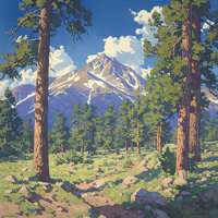
For those who don’t know, the Pacific Crest Trail is a long-distance hiking and equestrian trail that follows some of the highest pats of the Sierra Nevada and Cascade mountain ranges from Mexico to Canada, crossing Califoria, Oregon and Washington. It is 2,663 miles long, passes through 25 national forest and 7 national parks. The trail became a National Scenic Trail in 1968.
From Backpacker Magazine:
The Hike
The best section of the most scenic long trail in the country is the 203.7-mile stretch in the central Sierra from Kennedy Meadows Campground to Red’s Meadow Campground. In that span, the PCT crosses Sequoia and Kings Canyon National Parks and the John Muir Wilderness–and never meets a single road. It’s the longest roadless span on any National Scenic Trail in the country. On the way, you’ll have a chance to summit Mt. Whitney (the Lower 48’s highest point at 14,497 feet) and experience the legendarily gentle weather of California’s central Sierra. Plan for 10 to 15 days to cross this roller coaster of subalpine and glaciated terrain.
The Crux
River crossings in high, fast, freezing water. After a heavy snow year, creeks swell to 50 feet wide well into July.
The Key
Astute river scouting, patience, and a “got dunked” plan. The most challenging streams are Evolution Creek, Bear Creek, and the North Fork of Mono Creek between Muir Pass and Shelden Pass (miles 145, 162, and 175 respectively). The trail doesn’t always intersect them at the best place to ford, so scout upstream for shallower crossings. Evolution Creek, for example, is slower and braided into smaller segments just a third of a mile upstream. But strength in numbers is the real key, even if it means waiting for more hikers to show up. The most stable river-crossing method is the tripod: Three hikers unclip their hipbelts, place their arms on each other’s shoulders in a triangle formation, and cross slowly with the strongest hiker forming the upstream “point” of the triangle. Before you cross, be sure to look for downstream obstacles to avoid (like rocks, waterfalls, downed logs) if you lose your footing. And if you do go for a swim, immediately stop and warm up once you reach dry land: Build a small fire, make a hot drink, and eat a calorie-dense snack, like peanut butter. Still chilled? Do push-ups.
The Pacific Crest Trail, Appalachian Trail, and Continental Divide Trail are part of the Triple Crown of Hiking. According to Wikipedia, the total length of the three trails is about 7,900 miles with a total vertical gain of more than 1,000,000 feet. By the time you finish the Triple Crown, you’ll have visited a total of 22 states. The American Long Distance Hiking Association – West recognizes this accomplishment yearly.
You can read the rest of the article HERE.
You can find out more about the Pacific Crest Trail Association HERE.
You can find out more about the PCT at the U.S. Forestry Service website HERE.
You can find out more about the American Long Distance Hiking Association HERE.