
The Merced Wild and Scenic River Final Comprehensive Management Plan and Environmental Impact Statement was released in February 2014. The plan covers the more than 80 miles of Merced River that is within the Yosemite National Park and El Portal Administrative Site and is to serve as the framework to protect and manage river usage over then next 20 years.
From American Whitewater:
Late last week, the Merced River in Yosemite National Park was officially reopened to paddlers! Even though the new Wild and Scenic River Plan was finalized a year ago, the actual rules and regulations for the Park (the Superintendent’s Compendium) still needed to be updated. This finally happened on Friday, April 24, 2015, and is the culmination of seven years of sustained engagement by American Whitewater with the National Park Service and other stakeholders in this process. Allowing paddling was a tiny, yet important component of the grander plan to preserve the outstandingly remarkable values of the Wild and Scenic Merced River.
With a total of fifteen years and 21 million dollars invested into it, the Merced River Management Plan is the most extensive plan of its type ever produced. The narrow geography of Yosemite Valley, combined with the quarter mile Wild and Scenic boundary that extends on either side of the Merced River, meant that this plan would regulate virtually all activities in the Valley. In fact, that is exactly what the Judge said in ruling against two previous plans submitted by the Park Service.
American Whitewater was a vocal supporter of this final plan when it was released. Yes, we were pleased that this plan would open up previously closed sections of the Merced, but more importantly, this plan provided balance between a wide array of user groups and resource protection needs. To be clear, not all sections of the river have been opened and those sections that are open have user capacity limitations. The key success for paddlers, and one that American Whitewater fought hard to achieve, is that paddlers are treated on equal footing with other comparable uses. Early on we coined the phrase, “A river is a trail and a boat is a backpack.” Viewing boating through this lens made it easier to describe river use in a way that was consistent with how the Park manages other trails.
On April 13, we joined with Park Service staff to float the entire length of Yosemite Valley. Because the river had not officially opened yet, we got a special use permit from Superintendent Don Neubacher in order to float the river. Our group included a range of paddling history from Richard Montgomery (first to paddle the Grand Canyon of the Tuolumne), to long standing ARTA nonprofit manager Steve Welch, lifetime river advocate Bob Center and American Whitewater’s California Stewardship Director, Dave Steindorf. Yosemite National Park Chief of Staff Mike Gauthier also joined us, along with thirty river enthusiast/advocates.
“We want to embrace paddling, we want it to work, and we want it to be really successful and that’s what this whole day is really about,” Gauthier said on the morning of the inaugural paddle. Gauthier has been a strong advocate for paddling in the Park.
From Canoe and Kayak:
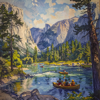
For paddlers, the Merced River in Yosemite National Park has been a particularly sweet forbidden fruit. While the river outside the park has long been a paddling hotbed, boaters have been forbidden from floating in the park’s backcountry and iconic valley. Until now. Yosemite National Park’s new Management Plan and Environmental Impact Statement for the Merced places paddling on the same footing as climbing and hiking within the park’s boundaries. The plan opens three coveted sections to paddling, including the Yosemite Valley, Merced Gorge and South Fork Merced.
The management plan was finalized in 2014 after seven years of negotiation between the park service, American Whitewater and other stakeholders, but the new rules only took effect on April 24, 2015.
The park will now treat kayaking and canoeing as “another way to travel through the landscape,” says American Whitewater’s California Stewardship Director Dave Steindorf. The plan considers river segments as “water trails” or backcountry routes, opening new segments to boating for the first time.
What’s all this spell for floaters? Official access to what Steindorf calls the “best one-day river trip you can do anywhere.”
The long and short of it:
- Raft and Gear Rentals are available at Curry Village Recreation Center (paddles and PFDs available for $5.50 ea.)
- Trip Length: ~3 Miles
- Difficulty: Class I
- Months: Late May/June through July/Early August (depending on conditions)
- Hours:10 a.m. – 6 p.m.
- Gage: Must Read less than 6.5 feet at Sentinel Bridge
- Possible hazards: Strainers, Cold Water, Cold Air
- Views of Half Dome, Yosemite Falls, Yosemite Valley
- Put-In Parking: Curry Village Recreation Center
- Kayak Put-In: Below Stoneman Bridge
- Take-Out: Sandy Beach on River Left after the wooden bridge
- Take-Out Parking: Sentinel Beach Picnic Area
You can read more about the new changes on American Whitewater HERE, Canoe & Kayak HERE, Adventure Sports HERE.
You can find out more about the inelegantly named “Merced Wild and Scenic River Final Comprehensive Management Plan and Environmental Impact Statement” HERE.
To find out more about rafting and kayaking opportunities through the Curry Village Recreation Center website HERE.
To find out more about Yosemite National Park you can check out the National Park Service website HERE.
Here’s a video of the Inaugural Paddle Merced River Clarks Bridge to El Capitan Meadow made on April 13, 2015: